Breaking
‘Dodong’ landfalls in Sta. Ana, Cagayan
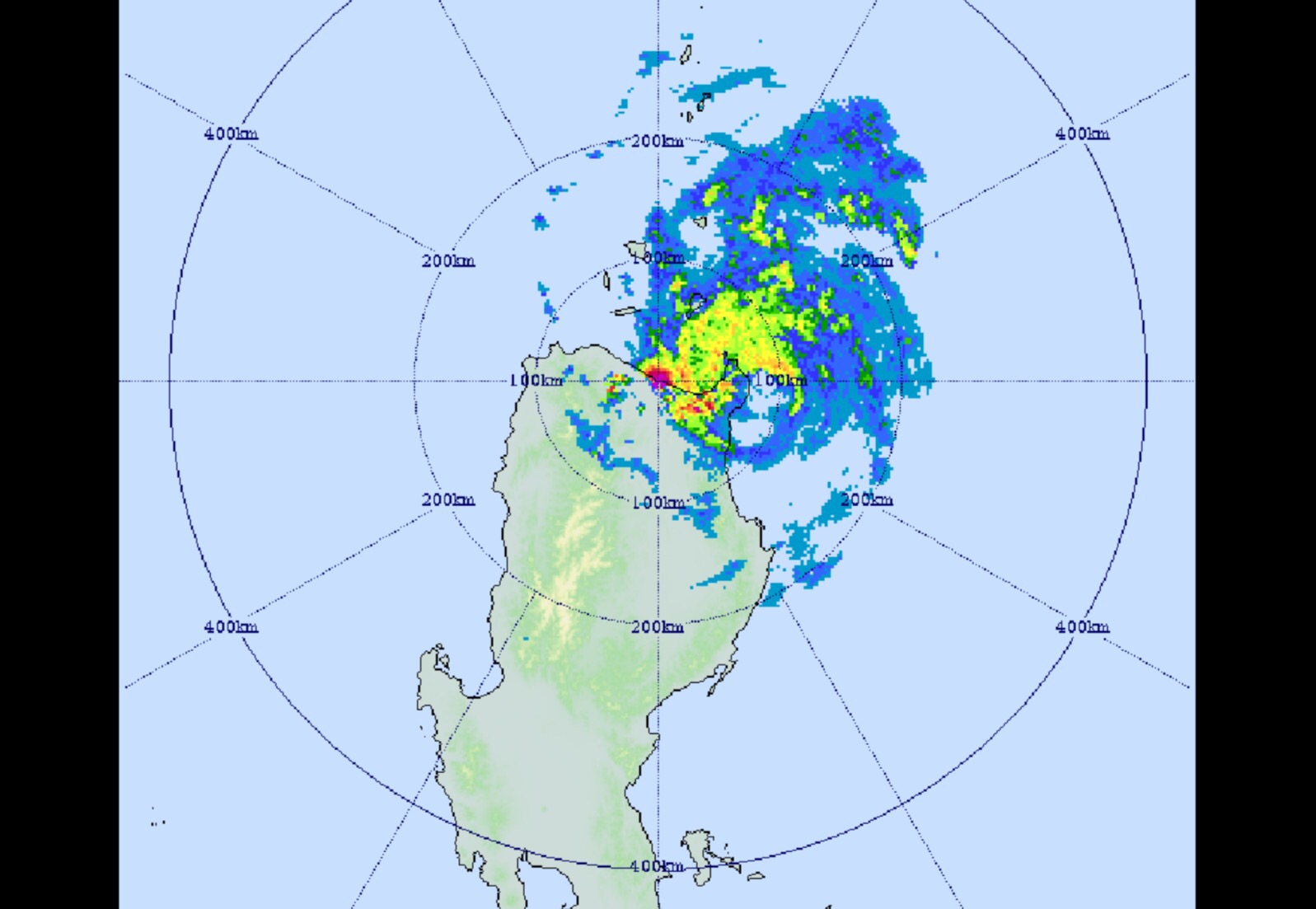
MANILA — Typhoon “Dodong” has already made landfall over Sta. Ana pt., Cagayan on Sunday afternoon, according to Philippine Atmospheric, Geophysical and Astronomical Services Administration (PAGASA).
In an interview, PAGASA weather forecaster Aldczar Aurelio said that Typhoon Dodong has made landfall over Pananapan Pt., Sta. Ana, Cagayan around 4:45 p.m. and expected to make another landfall in Batanes area on Sunday evening.
As of 4 p.m. the eye of Typhoon Dodong was located based on all available data at 95 km Southeast Aparri, Cagayan(18.1°N,122.5°E) packing maximum sustained winds of 185 kilometers per hour (kph) near the center while its gustiness is up to 220 kph
Typhoon Dodong direction moves north northwest at 17 kph.
With its current speed and movement, it will exit the PAR by Tuesday morning (May 12) headed towards Japan.
PAGASA said the provinces of Northeastern Cagayan, Batanes, Babuyan and Calayan Group of Islands, are still under public storm warning siganl no. 4 (with 171-220 kph expected in 12 hrs.)
The potential impacts of the winds under signal no. 4 were the following:
Very heavy damage to high –risk structures
Heavy damage to medium risk structures;
Moderate damage to low-risk structures
Considerable damage to structures of light materials (up to 75% are totally and partially destroyed); complete roof structure failures.
Many houses of medium-built materials are unroofed, some with collapsed walls; extensive damage to doors and windows.
A few houses of first-class materials are partially damaged
All signs/billboards were blown down. There is almost total damage to banana plantation.
Most mango trees, ipil-ipil and similar types of large trees are downed or broken.
Coconut plantation may suffer extensive damages.
Rice and corn plantation might suffer severe losses.
PAGASA said that areas under Signal No. 3 (winds of 101-185 kilometers per hour expected in at least 18 hours) are the rest of Cagayan, Apayao and Isabela.
The potential impacts of the winds under signal no. 3 were the following:
•Heavy damage to high–risk structures
•Moderate damage to medium- risk structures
•Light damage to low-risk structures
•Increasing damage (up to more than 50%) to old, dilapidated residential structures and houses of light materials. Majority of all nipa and cogon houses may be unroofed or destroyed
•Houses of medium strength materials (old, timber or mixed timber-CHB structures, usually with G.I. roofing’s); some warehouses or bodega-type structures are unroofed.
•There may be widespread disruption of electrical power and communication services
•Almost all banana plants are downed.
•Some big trees (acacia, mango, etc.) are broken or uprooted,
•Dwarf-type or hybrid coconut trees are tilted or downed.
•Rice and corn crops may suffer heavy losses.
•Damage to shrubbery and trees with foliage blown off; some large trees blown down.
The provinces of Northern Aurora, Kalinga, Mt. Province, Ifugao, Ilocos Norte and Abra are under signal no. 2 (Winds of 61-100 kilometers per hour expected in at least 24 hours).
The potential impacts of the winds under signal no.2 were the following:
Light to Moderate damage to high risk structures;
•Very light to light damage to medium-risk structures
•No damage to very light damage to low risk structure
•Unshielded, old dilapidated schoolhouses, makeshift shanties, and other structures of light materials were partially damaged or unroofed
•A number of nipa and cogon houses may be partially or totally unroofed
•Some old galvanized iron (G.I.) roofs may be peeled or blown off
•Some wooden, old electric posts were tilted or downed
•Some damage to poorly constructed signs/billboards
•In general, the winds may bring light to moderate damage to the exposed communities. Most banana plants, a few mango trees, ipil-ipil and similar types of trees were downed or broken
•Some coconut trees may be tilted with few others broken
•Rice and corn may be adversely affected
•Considerable damage to shrubbery and trees with some heavy-foliaged trees blown down.
Storm Surge is possible over coastal areas under PSWS # 2.
The public storm warning signal no. 1 (30-60 kph winds expected in at least 36 hours) is still hoisted over the rest of Aurora, Ilocos Sur and Quirino.
The potential impacts of the winds under signal no.1 were the following:
•No damage to high risk structures.
•Light damage to medium to low risk structures.
•Slight damage to some houses of very light materials or makeshift structures in exposed communities.
•Some banana plants are tilted, a few downed and leaves are generally damaged.
•Twigs of small trees may be broken.
•Rice crops, however, may suffer significant damage when it is in its flowering stage.
Residents in low lying and mountainous areas of the provinces with Public Storm Warning Signals are alerted against possible flashfloods and landslides.
Storm surges of up to 2.0 meters are possible over Gonzaga and Sta. Ana Cagayan.
Fisherfolk are advised not to venture out over the eastern seaboard of Southern Luzon.
They were advised to refrain from outdoor activities particularly along beaches of the eastern section of Isabela and Cagayan on Sunday (May 10).
Meanwhile, Public Storm Warning Signals elsewhere are now lifted.
The estimated rainfall amount is from heavy to intense within the 150 km diameter of the typhoon.
In its 24-hour forcast, PAGASA said stormy weather with rough to very rough seas will be experienced over Cagayan Valley, Cordillera, Ilocos Norte and Northern Aurora while Ilocos Sur and the rest of Aurora will have rains with gusty winds.
Cloudy skies with light to moderate rains and thunderstorms will be experienced over rest of Ilocos region and rest of Central Luzon while Metro Manila and the rest of the country will have partly cloudy to cloudy skies with isolated rainshowers or thunderstorms.
It added moderate to strong winds blowing from the Southwest to South will prevail over the rest of Luzon with moderate to rough seas.
Elsewhere, winds will be light to moderate coming from the Southwest to Southeast with slight to moderate seas.
The state-run weather bureau also issued a gale warning due to the effects of typhoon Dodong as the sea condition will be rough to very rough due to strong to gale force winds is expected to affect the eastern seaboards of Southern Luzon.
”Fishing boats and other small seacrafts are advised not to venture out into the sea while larger sea vessels are alerted against big waves,” it said. (PNA)