Philippine News
Satellite image shows China reclaiming land off Palawan
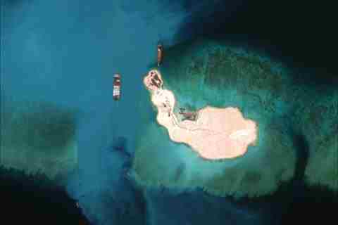
Center for Strategic and International Studies (CSIS) Photo
MANILA – Satellite images published recently show China building seawalls and several dredgers installed around a submerged reef within the Philippine’s exclusive economic zone.
An image published by the Washington-based Center for Strategic and International Studies (CSIS) showed a chain of small artificial formations and structures including fortified seawalls along Mischief Reef.
The said work on the Mischief Reef off Palawan coasts is the most recent reclamation activities of China in the disputed territories.
The activity along with six other reclamation in the Spratlys reef, has drawn criticism among other claimant countries.
The CSIS Asia Maritime Transparency Initiative also noted the presence of several dredgers and the expansion of the entrance of the reef.
Another image also showed a Chinese transport naval vessel capable of holding up to 800 troops and 20 amphibious armoured vehicles several hundred metres from the reef’s entrance.
“We are especially concerned at the prospect of militarization of these outposts,” Secretary of Defense Ash Carter in an interview with Japan’s Yomiuri newspaper.